

 |
|
The hurricane would be the strongest to strike the East Coast in seven years, and people were already getting out of the way. |
NAGS HEAD, N.C.—Hurricane Irene began lashing the East Coast with rain Friday ahead of a weekend of violent weather that was almost certain to heap punishment on a vast stretch of shoreline from the Carolinas to Massachusetts.
For hundreds of miles, people in the storm’s path headed inland, made last-minute preparations and monitored the hurricane’s every subtle movement. Irene had the potential to cause billions of dollars in damage all along a densely populated arc that included Washington, Baltimore, Philadelphia, New York, Boston and beyond. At least 65 million people were in its projected track.
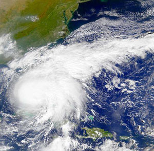
As the storm trudged toward northwest from the Bahamas, rain from its outer bands began falling along the North and South Carolina coast. Swells and 6- to 9-foot waves were reported along the Outer Banks. Winds were expected to pick up later. Thousands had already lost power as the fringes of the storm began raking the shore.
Forecasters expanded the hurricane warning area, which extended from North Carolina to Sandy Hook, N.J., south of New York City. A hurricane watch was in effect even farther north and included Long Island, Martha’s Vineyard and Nantucket, Mass.
Risks from Irene’s wrath were many: surging seas, drenching rains, flash floods and high winds.
“We’re going to have damages. We just don’t know how bad,” said Craig Fugate, director of the Federal Emergency Management Agency, which was making disaster plans for many states. “This is one of the largest populations that will be impacted by one storm at one time.”
Irene could also push crude oil prices higher if it disrupts refineries in Delaware, New Jersey, Pennsylvania and Virginia, which produce nearly 8 percent of U.S. gasoline and diesel fuel.
The hurricane weakened slightly Friday, dropping to a Category 2 storm with maximum sustained winds near 110 mph (175 kph). But some restrengthening was possible, and the storm was expected to be near the threshold for a Category 3 storm when it crosses the North Carolina coast, the National Hurricane Center said.
In North Carolina, traffic was steady Friday as people fled the Outer Banks and beach towns. A day earlier, tourists were ordered to leave the barrier islands, and many residents heeded authorities’ stern admonitions to get out.
At a gas station in Nags Head, Pete Reynolds wanted to make sure he had enough fuel for the long trip. The retired teacher spent part of Thursday getting his house ready for the hurricane. He and his wife then headed to New Jersey to stay with their son’s family.
“We felt like we would be OK, and we could ride out the storm,” Reynolds said. “But when they announced mandatory evacuations, I knew it was serious.”
Speaking Friday on CBS’ “The Early Show,” North Carolina Gov. Beverly Perdue said state troopers, the Red Cross and the National Guard were in place to deal with the storm’s aftermath. But she warned coastal residents not to risk waiting out the storm and hoping for help after it passed.
“You can’t count on that. Folks need to decide that they need to get out now,” she said.
North Carolina was just first in line along the Eastern Seaboard—home to some of the nation’s priciest real estate. Besides major cities, sprawling suburban bedroom communities, ports, airports, highway networks, cropland and mile after mile of built-up beachfront neighborhoods are in harm’s way.
“One of my greatest nightmares was having a major hurricane go up the whole Northeast coast,” Max Mayfield, the National Hurricane Center’s retired director, told The Associated Press on Thursday. “This is going to be a real challenge … There’s going to be millions of people affected.”
The hurricane would be the strongest to strike the East Coast in seven years, and people were already getting out of the way. After hitting the Bahamas, it was again moving over warm Atlantic waters that will energize it.
The center of the storm was still about 375 miles (600 kilometers) south-southwest of Cape Hatteras, N.C., and moving to the north at 14 mph (22 kph).
Hundreds of thousands of New Yorkers were told Thursday to pack a bag and be prepared to move elsewhere. The nation’s biggest city has not seen a hurricane in decades.
Farther south, farmers pulled up their crops.
North Carolina farmer Wilson Daughtry has lost count of how many times his crops have been wiped out by storms that develop in the tropics.
“That’s the price of living in paradise,” he said of a fertile farm belt that’s endured an unusually hot and dry summer. Any deluge from Irene’s rain bands could wipe out many crops just when they are ready for harvesting.
The latest figures show coastal North Carolina fields generated nearly $6.3 billion in farm income in 2009 alone from tobacco, corn and other crops.
The latest forecasts showed Irene crashing up the North Carolina coastline Saturday, then churning up the Eastern Seaboard, drenching areas from Virginia to New York City before a much-weakened storm reaches New England.
Even if the winds aren’t strong enough to damage buildings in a metropolis made largely of brick, concrete and steel, a lot of New York’s subways and other infrastructure are underground, making it subject to flooding in the event of an unusually strong storm surge or heavy rains.
New York’s two airports are close to the water and could be inundated, as could densely packed neighborhoods, if the storm pushes ocean water into the city’s waterways, officials said. The city had a brush with a tropical storm, Hanna, in 2008 that dumped 3 inches of rain on Manhattan.
In the last 200 years, New York has seen only a few significant hurricanes. In September 1821, a hurricane raised tides by 13 feet in an hour and flooded all of Manhattan south of Canal Street, the southernmost tip of the city. The area now includes Wall Street and the World Trade Center memorial.
An infamous 1938 storm dubbed the Long Island Express came ashore about 75 miles east of the city and then hit New England, killing 700 people and leaving 63,000 homeless.
New England is also unaccustomed to direct hits from hurricanes.
Maine lobsterman Greg Griffin, who fishes from Portland, still recalls the clobbering from Hurricane Gloria in 1985 and said Irene is not one to ignore.
“We have a young generation of lobstermen who’ve never experienced a full-blown hurricane,” Griffin warned.
The first U.S. injuries from Irene appeared to be in South Florida near West Palm Beach, where eight people were washed off a jetty Thursday by a large wave churned up by the storm.
In Washington, Irene dashed hopes of dedicating a 30-foot sculpture to the late Martin Luther King Jr. on Sunday on the National Mall. While a direct strike on the nation’s capital appeared slim, organizers said the forecasts of wind and heavy rain made it too dangerous to summon a throng they expected to number up to 250,000.
Across the Northeast, Irene threatened to flood many miles of land that are already saturated from heavy rain.
Parts of Rhode Island are still recovering from devastating 2010 spring floods. Connecticut Gov. Daniel P. Malloy warned there could be prolonged power outages if Irene dumps up to a foot of additional rain.
The urban population explosion in recent decades also worries New Jersey officials. Gov. Chris Christie encouraged anyone on that state’s heavily built-up shoreline to begin preparations to leave. One of the popular casinos in Atlantic City had already closed Friday, and several others planned to shut down later in the day.
The beach community of Ocean City, Md., was taking no chances, ordering thousands of people to leave.
“This is not a time to get out the camera and sit on the beach and take pictures of the waves,” said Maryland Gov. Martin O’Malley.

|